Kenilworth Castle and Abbey Trail
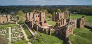
Welcome to Kenilworth, a place most definitely worth your time…step into our monumental story amongst the noble ruins of Kenilworth Castle. Lose yourself in the rolling greenery of Abbey Fields, or venture just a little further into beautiful countryside alive with nature. Spend a day uncovering the rich threads of our history, browse intriguing shops or simply kick back over some fabulous food & drink.
But wait, there’s more here than you’d think So, slow down, savour each moment and…
Discover the story for yourself…
Uncover the monumental tale behind Kenilworth’s greatest treasures! A tale of love, death, triumph and tragedy all played out across the ruined stones of the Castle and the Abbey. Uncover the truth, shatter myths and enjoy a journey through some of the greatest moments of Kenilworth’s history.
The walk is around 3.5 miles and takes approximately 2 hours (not including a visit to the Castle). The route is mostly on roads and paths, but can be muddy in winter, particularly on the site of the mere, however the views and stories make it worthwhile!
The Beginning
In 1119 King Henry I granted land on the Royal Manor of Stoneleigh to his Chamberlain Geoffrey de Clinton. On the king’s orders, Geoffrey built a Castle to the west, raising a stone keep on a sandstone outcrop protected by marshy ground. This made the castle a formidable stronghold and a key defence of Henry’s realm east of the Forest of Arden. Geoffrey further gifted land (the current Abbey Fields) for the establishment of an Augustinian Priory. Take Forrest Road to the Junction. Turn right, cross Borrowell Lane and then turn left on the small road and bear right behind houses to reach woodland. On leaving woods turn right and follow the track to the gate next to the Castle ticket office.
The Castle Defences
Around 1210 King John built the Castle’s outer walls and towers, with stone from the quarry on the hill behind you.
The defences were further reinforced by earthworks on this side of the brook (known as the Brays), likely topped with a wooden palisade. In 1266 after the death of the rebel Simon de Montfort, Sir Henry de Hastings refused to surrender
the Castle, holding it in the name of Simon’s wife and son. In response, King Henry III laid siege to the Castle for almost six entire months. Trebuchets hurled 300lb stones against the walls, although they would prove ineffective against the sturdy defences. Continue west on the footpath through three gates.
The Mere
The walls were not the castle’s only defence however, Finham Brook was dammed at the tiltyard to create a huge artificial lake. The “Mere” was 1.2km long and in places 152m wide defending the Castle on two sides and creating a moat on the others. These formidable defences kept Henry’s siege engines at a distance and forced an unsuccessful night-time assault using barges hauled overland. In later times the Mere became more of a royal pleasure lake for boating, hosting regattas, and as a backdrop to firework displays. Turn right along the track and continue through two fields to reach the Pleasance.
The Pleasance
In the early 15th century, Henry V built the “Pleasance in the Marsh”, a secluded banqueting lodge hidden away here on the edge of the Mere. Reachable by boat, the four-acre site comprised a rectangular moated earthwork topped by timber buildings, with stone towers at each corner, and enclosing a courtyard garden. Sadly, it was demolished on the orders of Henry VIII in 1524.
The land around the Mere had been used as a royal hunting park since the 14th century but around 1565 Robert Dudley expanded this by 800 acres to create a walled hunting forest or “chase”. Take the gate to your right and continue on footpath to Purlieu Lane. Continue until Castle comes into view.
Elizabeth I & Robert Dudley
Over time the castle developed from fortress to palace; John of Gaunt added the immense great hall and Robert Dudley undertook extensive works in anticipation of the visits by Queen Elizabeth I. He also constructed a 183m bridge over the mere to give access to the chase. Much has been written of their “romance” but “Kenilworth” by Sir Walter Scott is the most famous (albeit fictional) representation. A theory suggests a young William Shakespeare may have visited in 1575 with this view inspiring Theseus’ Palace in a Midsummer Night’s Dream. Continue along Purlieu Lane, turning right through the gate.
Golden Age and Decline
Dudley spared no expense for Elizabeth I’s visit in 1575 with lavish pageants, hunts, barge cruises and fireworks over the Mere. The castle was taken by parliamentary forces in 1642, and its defences dismantled, including breaching the dam at the tiltyard to empty the Mere (known as Hawkesworth’s gap). The castle deteriorated, and although famous as a tourist attraction, its stones were reused elsewhere in Kenilworth, with only Leicester’s Gatehouse maintained. In 1937 car manufacturer Sir John Siddeley bought the castle and in 1958 the freehold passed to Kenilworth Urban District Council.
Castle Hill
In July 1266 Papal Legate Cardinal Ottobuono (later Pope Adrian V) excommunicated the castle’s defenders, from beyond catapult range on Castle Hill. It did not have the intended effect as a defender dressed as the papal legate subsequently returned the favour to the King and his army! However, by December 1266 famine and disease had finally bought the siege to an end.
The cottages of Little Virginia date from the 17th century although there is evidence of earlier structures and stone working indicating housing for masons in Dudley’s time. Excavation in 1973 also discovered a sandstone wall that would have marked the boundary of Abbey lands. Continue uphill, turn right into Abbey Fields. Follow the tarmac path downhill.
The Abbey Gatehouse
The Augustinian priory of St Mary the Virgin was founded in 1119. It became one of the largest in the Midlands and in 1447 the Pope raised it to Abbey status. Dissolved in 1538 it was stripped of its wealth, much of its stone re-cycled (mainly by Robert Dudley) and it was left to ruin. The 1370 Gatehouse, was the main entrance to the abbey, manned by a porter who lodged in the adjacent two-storey rooms. A wall or further structures would have created a courtyard extending to the museum and the cloister. Walk east from the gatehouse through the churchyard, the southern part of the ruin is the Outer Parlour.
The Abbey Ruins
The Outer Parlour was where visitors were received. Extending southwards was a wing of storerooms with possibly guest accommodation above. Henry III would have likely lodged here during the siege. Ahead is the square Cloister which extended
beyond the churchyard wall. The Cloister was surrounded by a * covered arcade lined with seating, for the canons to work. Part of the north wall (the “Lapidarium”) was rebuilt in 1984 using decorated stonework discovered in the 1922 excavations. Take the steps into the nave.
The Abbey Church, whilst dating from the Abbey’s founding was extended under the patronage of John of Gaunt. This created a vast church with walls 45ft high that ran some 283 feet to the high altar at the far eastern end. The canons would have attended prayer here eight times a day. Excavations have uncovered numerous tombs including that of at least one prior. Up a level to your left are the remains of the octagonal Bell tower, built separately due to the weight of the bells. Return to the nave, walk east along its length and bear left at the churchyard wall.
St. Nicholas Church
Dating from 1291 St Nicholas provided a place of worship for the community who were not allowed in the Abbey. It features several Abbey remnants, including the West Door – built from Abbey stones in a renaissance frame. On her visit in 1575 Elizabeth I attended two services here so the door may have been part of Dudley’s efforts to impress. Inside are carved stone seats from the Abbey and a “pig of lead”, discovered in 1888. Often thought to be the Abbey’s roof, it could be one (or several) of the Abbey’s bells, melted down after dissolution (and therefore not lead either!). Return to the churchyard wall and follow the outside southwards towards the large ruined wall.
The Chapter House
Much of this green space would have been occupied by buildings, including the two-storey infirmary to the south
east and the dormitories and latrines which ran south as far as the tennis courts. Used for meetings, the Chapter House was a large building 15m long and 8.5m wide, decorated with ribbed vaulting and Romanesque arches. The visible wall is actually just the tip of the iceberg and would have been over 20m high and 2m thick! Excavations in 1922 uncovered two stone coffins, and theories abound that these are the tombs of Geoffrey de Clinton, his son or the first prior of the Abbey. Follow the churchyard wall then turn left at museum and bear right around the Swimming Pool.
Abbey Pool & Fields
To support the Abbey, the surrounding land was given over to food production with orchards, a vineyard, pastures and gardens. A dam, constructed c1200, coreseated the Abbey Pool (roughly on the site of the modern lake). This was stocked with fish and powered a watermill on the south bank of the brook. A bridge over the brook has existed since the 12th century although it was washed away and replaced at least twice. Following dissolution, the land remained private, but a concerted effort over the last 150 years has made it a public space. Continue around the Swimming pool to iron bridge. Turn right uphill back to the War Memorial and Abbey End.
Download a PDF of the Kenilworth Castle and Abbey Trail
Discover more of Shakespeare's England
Things to Do
There's so much to see and do in Shakespeare's England!
Stay
Amazing accommodation to suit all budgets and tastes.
Food & Drink
Find something truly tempting to tuck into.
What's On
Explore a variety of fantastic events.
Follow us on Instagram


